


Christophe
-
Posts
3,939 -
Joined
-
Last visited
-
Days Won
1
Content Type
Profiles
Forums
Blogs
Gallery
Events
Store
Everything posted by Christophe
-
Another example : the French Academician H?l?ne Carr?re d'Encausse. Ch. Pic : AFP - Fefelberg.

-
Soviet Soviet & Eastern Block Quiz
Christophe replied to Christophe's topic in Russia: Soviet: Other Militaria
Jan, I agree with you. I have the "magic" figure of 4.569.893 medals awarded. For the bravest soldier, I have the information he has been awarded this medal 4 times!! For Dudeman, is this correct ? For all, any idea of the identity of the "bravest" ? Ch. -
Soviet Soviet & Eastern Block Quiz
Christophe replied to Christophe's topic in Russia: Soviet: Other Militaria
So, no one to try ? Cheers. Ch. -
DMZ - North Korea / South Korea
Christophe replied to Christophe's topic in Modern Campaigns and Conflicts
I have many more pics to post if you are interested in. Please, don't hesitate to ask for them, or post any comment. I am sure some of you will have in mind "souvenirs". I hope you enjoyed this short tour of the DMZ. Cheers. Ch. -
DMZ - North Korea / South Korea
Christophe replied to Christophe's topic in Modern Campaigns and Conflicts
And, to conclude this short tour of the DMZ, here is a pic of the model of Panmunjeon, as displayed in the War Memorial of Korea, in Seoul. In this model, the North is on he right, the South on the left. I can only recommand its visit. Ch. Pic : ? Christophe - ChR Collection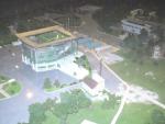
-
DMZ - North Korea / South Korea
Christophe replied to Christophe's topic in Modern Campaigns and Conflicts
Dorasan station. The station is on the left. Ch. Pic : ? Christophe - ChR Collection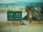
-
DMZ - North Korea / South Korea
Christophe replied to Christophe's topic in Modern Campaigns and Conflicts
The "official" stamp put on our passport at Dorasan, indicating you are ready to embark for the North. A peaceful message for a future unified Korea... Ch. Pic : ? Christophe - ChR Collection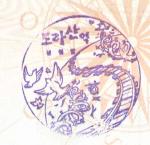
-
DMZ - North Korea / South Korea
Christophe replied to Christophe's topic in Modern Campaigns and Conflicts
A sign you don't see everwhere... Ch. Pic : ? Christophe - ChR Collection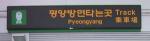
-
DMZ - North Korea / South Korea
Christophe replied to Christophe's topic in Modern Campaigns and Conflicts
The station is empty with the exception of a few employees, and a soldier guarding the access of the plaform to Pyongyan. This is the last stop before the North. Everything is ready for the unification of the two Korea. Ch. Pic : ? Christophe - ChR Collection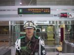
-
DMZ - North Korea / South Korea
Christophe replied to Christophe's topic in Modern Campaigns and Conflicts
Dorasan Station The station is ready for welcoming passengers of the line from Seoul to Pyongyang. A really brand new train station operational at Dorasan, the last stop before the demarcation line. Ch. Pic : ? Christophe - ChR Collection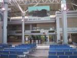
-
DMZ - North Korea / South Korea
Christophe replied to Christophe's topic in Modern Campaigns and Conflicts
The two Korea face to face. Ch. Pic : ? Christophe - ChR Collection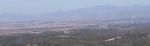
-
DMZ - North Korea / South Korea
Christophe replied to Christophe's topic in Modern Campaigns and Conflicts
South Korean "Freedom Village" South Korean "Freedom Village" of Taesong-Dong, with its 100m high flagpole and its flag, clearly visible. Ch. Pic : ? Christophe - ChR Collection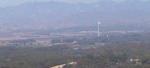
-
DMZ - North Korea / South Korea
Christophe replied to Christophe's topic in Modern Campaigns and Conflicts
North Korean "Propaganda Village" North Korean "Propaganda Village" of Kijong-Dong, with its 160m high flagpole (visible in the center. Ch. Pic : ? Christophe - ChR Collection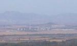
-
DMZ - North Korea / South Korea
Christophe replied to Christophe's topic in Modern Campaigns and Conflicts
Demarkation Line. This pic, as the previous one, has been taken without previous authorization. The guard permitted me to keep it... Ch. Pic : ? Christophe - ChR Collection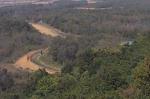
-
DMZ - North Korea / South Korea
Christophe replied to Christophe's topic in Modern Campaigns and Conflicts
North Korea View from the Mt Dora Observatory. From left to right : * Gaesong economic free zone (extreme left), where intensive building works of new factories currently take place. Located in North Korea, but financed by the South. * Demarkation Line. * North Korean "Propaganda Village" of Kijong-Dong, with its 160m high flagpole bearing the North Korean flag. * South Korean "Freedom Village" of Taesong-Dong, with its 100m high flagpole. From this pic, all these are not so evident to see. But in real, you see them quite well. I even saw farmers in North Korean fields. I'll post more detailed pics later. Ch. Pic : ? Christophe - ChR Collection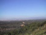
-
Soviet Stuff you don't see everyday
Christophe replied to Dudeman's topic in Russia: Soviet Orders, Medals & Decorations
Gerd, This would be logical... but pictures show they often wear them on their daily clothes (or what seems to be). Cheers. Ch. -
DMZ - North Korea / South Korea
Christophe replied to Christophe's topic in Modern Campaigns and Conflicts
Mt. Dora Observation Platform. This Observatory is located nearby the 3rd Tunnel. It is the place where you can see the most possible of North Korea. From this observation platform, North Korean military personnel are visible, and so are the city of Gaeseong (now a free economic zone) and the Geumgangsan Diamond Mountains. The two civilian villages at Panmunjeom are clearly visibles, as are the two giant flag poles. Inside is a big animated map of the area, and you have to follow a briefing of the South Korea Army. Outside, with goggles for more details, you can see North Korea. You can see the platform goggle on tle left of the pic. Ch. Pic : ? Christophe - ChR Collection
-
DMZ - North Korea / South Korea
Christophe replied to Christophe's topic in Modern Campaigns and Conflicts
Monument for the unification of Korea (site of the 3rd Tunnel). Ch. Pic : ? Christophe - ChR Collection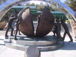
-
DMZ - North Korea / South Korea
Christophe replied to Christophe's topic in Modern Campaigns and Conflicts
The 3rd Tunnel. It is possible entering either by foot (what I did, with a safety helmet), or by taking a small monorail down to about the middle of the tunnel. By foot you can walk until the frontier (demarkation line) which is sealed, and permanently guarded. Ch. Pic : Korea Tourism Organization.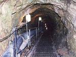
-
Soviet Stuff you don't see everyday
Christophe replied to Dudeman's topic in Russia: Soviet Orders, Medals & Decorations
Would it be to allow the wear of them on a civil suit ? Ch. -
DMZ - North Korea / South Korea
Christophe replied to Christophe's topic in Modern Campaigns and Conflicts
The entrance seen from the parking lot. The building of the previous pic is on the right. The entrance of the "green "tunnel" is clearly visible, going underground... just behind the soft drinks machines . Ch. Pic : ? Christophe - ChR Collection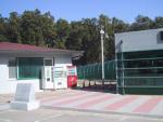
-
DMZ - North Korea / South Korea
Christophe replied to Christophe's topic in Modern Campaigns and Conflicts
The 3rd Tunnel This tunnel was discovered on 17 October 1978. It is located 52km from Seoul. South Korea has in total discovered 4 tunnels leading from the North to the South. They are named according to the order they were found. The 3rd tunnel is the closest to Seoul leading South Koreans think it was built for the purpose of invading Seoul. Approximately 10,000 soldiers can move through this tunnel in one hour. Photos were allowed only at the parking lot of the 3rd tunnel. Entering the tunnel, pictures were forbidden. Here is the entrance of the 3rd tunnel. On the pic, the entrance is in green, where the tunnel begins going under. Ch. Pic : ? Christophe - ChR Collection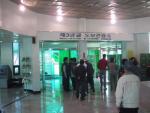
-
DMZ - North Korea / South Korea
Christophe replied to Christophe's topic in Modern Campaigns and Conflicts
Inside the DMZ Now, we take a bus, which is mandatory to enter the DMZ, as private cars are not authorized. Your passport (you have registered yourself several days in advance) is controlled at a checkpoint, and you are not any more allowed to take pictures, except in the points where it is mentioned as allowed. In the bus is a "commentator / tour operator" who describes what you see in a very "propaganda style" manner . This "commentator" is also there for checking you respect regulations : no photos, yellow lines not to cross... You enter the DMZ through a network of checkoints, chicanes, barbed wires fences... and firstly cross a bridge in slaloming between chicanes. After this first "test", the road to follow will be more straight : you just follow the road... sometimes between very close mined areas (explicit labels along the road). The pic taken here shows a defense obstacle. You see them just at the fringe of the DMZ, before entering it. A kind of huge concrete bridge full of all types material (explosives, stones, concrete... what I have been said) in its upper part. If the North troups are on the way, the South has just the time to make it "open" and dump its content on the road, blocking it!! I have seen several of these bridges... Sorry for the quality of the pic... but it is a "stolen" one. Ch. Pic : ? Christophe - ChR Collection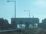
-
Soviet Stuff you don't see everyday
Christophe replied to Dudeman's topic in Russia: Soviet Orders, Medals & Decorations
This system presents similarities with more recent Mongolian attachment systems. In fact, with other orders, my first guess would have been that these awards have been attributed to a foreigner, who adapted the attachment system to something similar to what he is used to have... But, this does not seem to be the case, here. Interesting. Cheers. Ch. -
DMZ - North Korea / South Korea
Christophe replied to Christophe's topic in Modern Campaigns and Conflicts
Ch.


